2020 Will Be a Busy Year
This upcoming year is shaping up to be busy, and planning for the Arizona Trail (click the link to the left for the planning page) hike has crept up on me quickly. I’m planning on an early spring hike in 2020. In addition to two small businesses that I hope to roll out in Q1 and Q3 of next year, I’m also planning to go back and hike the Colorado Trail at the end of the summer. These four things, coupled with a wedding, will keep me hopping!
Arizona Trail Description
The Arizona Trail stretches across Arizona from Mexico to Utah. This National Scenic Trail is approximately 800 miles long and designated primitive, traversing numerous mountain ranges and ecosystems. I fell in love with desert hiking in Southern California and New Mexico, and I’m also one of those crazies that love the Great Divide Basin. Although the Basin is not desert, it still has that open, arid landscape that I find beautiful.
In addition to the open desert landscape that I enjoy, I’m also pretty excited that the trail travels through the Grand Canyon. Believe it or not, I’ve never actually visited this National Park. Being able to hike straight down through the canyon will be a highlight of the trip for me!
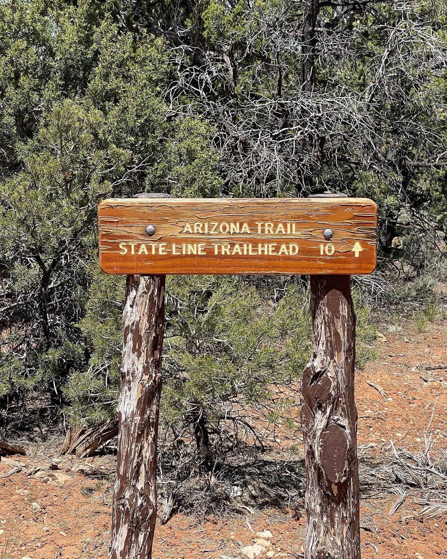
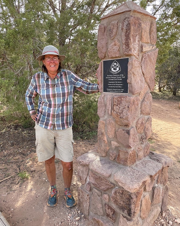
Arizona Trail Planning – NOBO Start
I plan to start the Arizona Trail on the Mexican border in early spring and head north to Utah. I may see some weather extremes based on March and April weather reports. Temperatures can range from the low 20s to the mid-50s at night. During the day, I could see mid-50s to mid-80s.
As with most backpacking, a lot depends on elevation. Snow, this early in the season, is not uncommon. In other words, I could wake up to below-freezing temperatures in the morning and hike down into a mild oven a few hours later. Being a cold weenie, I’ll take my 10-degree sleeping bag and carry it for the entire trail.
Arizona Trail Hike – Resources
The Arizona Trail has a strong community, and the Arizona Trail website (azt.org) provides good resources for all users of this trail. I recommend becoming a member and taking advantage of their valuable resources and updates.
Trail Maps/GPS
In addition to Guthook, I’ll also take the topo maps provided on the Arizona Trail website (azt.org). They are available with a membership. I see more and more people using only a GPS or GPS App for their hikes, but I always take a compass and maps. Electronics can be less than dependable in bad weather or frigid temperatures. I’m a firm believer in contingency planning.
Trail Guides
The Arizona National Scenic Trail Guidebook is downloaded on my phone via Kindle. The Guide provides excellent information about the trail, ecosystem, history, etc. Downloading it on my phone means I don’t have the extra weight. I’m not an ultralight hiker, but I still try to keep my base pack weight below 12 lbs.
Databook
Azt.org provides a Databook with a membership. This Databook includes mileage, water sources, elevation, campsites, etc., and a lot of helpful information which is only available to members. I’ve used the data books on many well-marked trails almost exclusively. This was the case for me on both the AT and the PCT.
Trail Community
The Arizona Trail has an active community. They provide good information on their website, and they keep it updated. Their Facebook Group is active, providing timely updates and assistance to hikers. If you join their group and have questions, you can expect to get a multitude of quick responses. I’ve watched as hikers inquire about rides and often get multiple replies.
Arizona Trail Planning – Logistics
Since I will be hiking NOBO on the trail, I plan to fly into Tucson. To reach the southernmost point on the trail, I’ll shuttle to Coronado National Memorial Visitor’s Center and Montezuma Pass and then hike south 1.8 miles to the monument on the border. From the monument, I’ll turn and begin my trip North.
Resupply
On my last few hikes, I did not cook and resupplied in the towns I passed through on the hike. Following my previous 10-day hike, I went to the Doctor for some tests and was shocked at my cholesterol and glucose levels. Once I gave the results some thought, I was not surprised. Junk food is the name of the game when I hike. The sugars, carbohydrates, and fats are great energy boosters, and being able to eat anything I want and still lose weight is addictive.
When I hiked across Connecticut for a few days during the Fall, I took my cook set (See Fall Post Here). I took healthier foods and enjoyed the hot meals. I realized eating had become a chore for me, and I had forgotten how much I enjoyed the variety of food found in cooking. Dehydrated food, combined with the cooking kit, was no heavier than cold foods without the kit. I will be cooking on the AZT hike, and I’m looking forward to it. I plan to try various dehydrated and freeze-dried foods and provide feedback on each. My hike after that might even include some of my dehydrated foods!
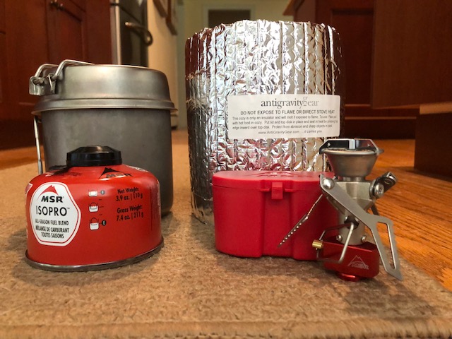
Because of my cooking changes, I’ll mail my resupply packages to towns along the trails. I’ll be able to ensure I have food I like to eat and healthier food. I’m sure I’ll supplement some along the way, but I’ll prepare most of my food ahead of time. A good list of all towns or “Gateway Communities” is also listed at azt.org.
Timing
My plan involves averaging 20 miles/per day. Based on terrain and elevation, I expect this to be reasonable. This includes going into towns for resupply and staying overnight to clean up. Many of the trails in this town are small, so in some cases, I’ll grab my packages and head out. I have to be home for a wedding by the beginning of May, but even if I take a little time for the Grand Canyon, I expect to have time to finish.
Arizona Trail Input
I know there are some Arizona Trail Alumni on my social media. As with all trails, I welcome all feedback and opinions. First-hand knowledge of trails often trumps any guidebook or map information, so please feel free to leave any comments or feedback on this trail. Thanks!


Desert hiking is definitely some of the best. Looking forward to the read!
Thanks! ?
Wow, for a minute I thought it was you getting married and my first thought was “NO, DON’T DO IT! I am planning an early spring hike on the Sheltowee Trace Trail.
It looks like a beautiful trail! Are you hiking the whole thing in one shot?
Have a good hike! I was always concerned about hiking in the desert but was pleasantly surprised by the number of water sources in southern Arizona. . I thought I would be drinking a lot of green pond water but many of the sources were from ranchers that had a well or spring feed a large metal tank!!!!
There are a fair number of wildlife tanks (that use roofing materials to channel water into concrete and metal storage tanks.) Be sure to read comments by hikers in Guthook about water sources.
Since you are NOBO, the wildlife tank near Winter Road (about 10 miles before the northern terminus) will hopefully be an excellent water source.
If you see Mr Bean’s comments in Guthook, that will be me.
Thanks for the intel!
Sure!