New England Trail Overview
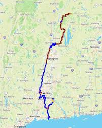
The New England Scenic Trail (NET) is a 215-mile hiking trail that travels through 41 communities in Connecticut and Massachusetts. The NET is comprised primarily of the Mattabesett, Metacomet, and Monadnock Trail systems and was designated a National Scenic Trail on March 30, 2009.
There have been two main changes to the trail since it was designated a National Scenic Trail in 2009. These include the following:
- A 4-mile extension to Long Island Sound in Connecticut.
- A 22+ mile eastward deviation from the historic Metacomet-Monadnock Trail in Massachusetts.
On These Trail Pages
You will find additional information on the Overview, Gear, and Planning pages. The goal of these pages is to make hiking this trail easier and to answer questions you may have about The New England Trail
- The body of the main page includes blog posts for each section as they are completed. These posts include trip reports and pictures to provide a snapshot of the trail on a specific section. The Planning page will provide a summary of these posts.
- This Overview page provides general information on the trail.
- The Gear page provides information about what I pack for day hikes along the New England Trail.
- The Planning page will help you when planning your hike. It has “How To” information, so you can find trailheads and determine where to park. The Planning page will provide tools for trail updates and learning more about events and activities.
New England Scenic Trail Highlights
- The NET travels through New England landscape features, including rural towns, forests, and large river valleys.
- The trail also travels through colonial historical landmarks.
- There is a wide range of ecosystems and natural resources: mountain ridges and summits, forest glades, wetlands, lakes, streams, and waterfalls.
- The NET has five overnight sights in Mass and three in Connecticut. These include tent sites and shelters.
- Stealth camping is not permitted since much of the trail travels through private property.
- The trail follows the Metacomet trap-rock ridge line in Connecticut and Massachusetts.
- Nearly 2 million people live within 10 miles of the trail.
- The southern terminus is in Guilford’s Chittenden Park on Long Island Sound, just a few miles south of I-95.
- The northern terminus is south of Mt. Monadnock at the NH/MA state border.
- The 165-foot-tall Heublein Tower offers panoramic views of Hartford, Connecticut, and the Farmington River Valley.
- Castle Craig, located on the East Peak in the Hanging Hills, is a 32-foot-high observation tower built of local basalt rock.
- The Seven Sisters, an expanse of ridge-line summits in Massachusetts’ Mount Holyoke Range, offer beautiful views and an overall elevation change of 3,700 feet.