March 22, 2022
Today proved to be a logistics challenge due to Saguaro National Park. I had tried to get a reservation at Grass Shack Campground and Manning for two weeks with no luck. The Arizona Trail went straight through the park and we could only camp at designated campsites.
The issue was that it would take just over 17 miles to go from park boundary to boundary, climbing thousands of feet. This early in the hike, Cricket did not have her trail legs yet and would not be able to do that mileage.
Most hikers camped at the border, got up early the following day, and hiked through, but the issue was not time. The issue was hiking 17 miles within a 24-hour window. The blisters on Cricket’s feet emphatically said, “HELL NO!”
Saguaro was a little frustrating. I could have gone straight through; most thru-hikers I know could have. The issue is those backpackers that can’t hike 17 miles in a shot. When I did get to Grass Shack early the following day, only one campsite had campers in it. No others had shown up. It would be good if Saguaro offered some of the processes used by other National Parks.
- Smokey Mountains on the AT – Thru-hikers get a permit for the park at the boundaries before they enter. They can stay in whatever shelter. If other hikers with reservations fill the shelter, they can camp near it.
- Glacier on the CDT – Hikers go to the backcountry office and get site permits the day before hiking through the park. It is not hard, but mileage can vary greatly depending on availability. For example, a site may be 9 miles one day and 23 the next. You need to be able to hike the longer miles.
- Grand Canyon on the AZT – Like Glacier, hikers go to the backcountry office the day before or the day of the hike and get a permit for the “thru-hiker” site. You will either be at Bright Angel or Cottonwood.
We decided to hike late into the night and discussed night hiking to the northern park boundary, but I was pretty sure that would not happen.
We were up and moving early. The wind had sufficiently pummeled us and stopped a half hour before we moved stiffly out from under our sand-covered quilts. I hiked ahead, and we agreed to meet at Rincon Creek for lunch, about 6.5 miles away. This would allow me time to loiter and try once more for a campsite reservation once I get a signal.
La Sevilla Picnic Area was my first stop since it had bathrooms. This area is super interesting (I like history) since many buildings were built by the CCC (Civilian Conservation Corp). So I poked around, used the facilities, and got a little more water before heading out.
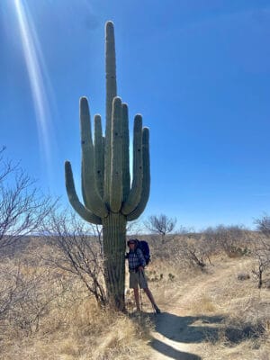
Between Colossal and Saguaro is one of my favorite sections of the trail. It is like a botanical garden with various cacti and smooth park-like paths. I’ve hiked it before, but this time it was quiet. The last time I played dodge the mountain bike – all of them were polite and friendly except for the one woman that screamed at me to move. One of us almost became impaled on a barrel cactus!
I stopped several times for photos and called home to chat and catch up. Reservations were a bust, but I felt a tad bit better for trying since I knew there was a possibility we were going to break a rule or two. I’m not a great rule follower, but I try if the intent is logical and reasonable.
Reaching Rincon Creek, I spread out for a nice long break and waited for Cricket. We had lunch and discussed our options. We decided to hike as long and far as possible, so after a nice long rest, we began our climb into the Rincons.
Cricket was feeling strong, and we made good time until about 4 PM when she began to lose her wind and start discussing camping options. At 5 PM, the hunt for campsites would often begin. True to pattern, the discussions and search began. This was when I usually tried to squeeze out a few more miles.
I would usually target what appeared to be a flattish area on the topo maps, and today was no exception. Once we reached that target, I always found it too angled and rocky and insisted we continue looking. Today, this went on for two hours until just before dark. No spot was good enough, so we continued climbing. My balking at camping spots got us at least two more miles.
Finally, I knew we would be going no further by dark, and night hiking would not happen, so I suggested a large flat rock to cowboy camp on for the night. We would not impact the vegetation around us; water was just up the trail. Although I wish we had made it out of the park, this was one of my favorite camping spots on the hike.
We ate dinner and settled into our quilts when the winds began picking up. Within an hour, it felt like a hurricane had hit. I was being battered and sandblasted. The trail was letting us know of its disapproval. I squished down, put my backpack on the side the wind was blowing from, and got some slight relief.
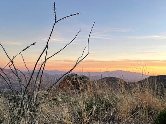
It was a tough night, reminding me of the southern PCT, but the sunset and sunrises were fantastic, so it did not matter that every wrinkle on my weathered skin was filled with grit!